 |
 | |||||||||||||
Surviving the Landfall of Hurricane Katrina
|
 |
||||||||||||
|
August 29, 2005. This morning, shortly before dawn, I am abruptly awakened by silence. The hum of my hotel room air conditioner has quit. The glow of the TV is now dark. Electricity is dead. The only sound now is that of a roaring, muffled wind on the other side of my Gulfport, Mississippi, fourth-floor hotel window.
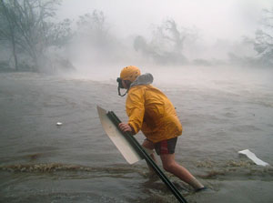
I pull back the drapes and peer outside. The sky is a light, cool blue. Oak trees sway convulsively. Small swirling debris litters the air. Fellow severe weather photographer Mike Theiss and I quickly check radar on a laptop computer. Seven days of forecasting and second-guessing Nature have verified: We're in the direct path of Hurricane Katrina, the fourth most powerful tropical cyclone to ever form in the Gulf of Mexico. Our goal is to document Katrina's maximum winds and storm surge.
Our plan to document Katrina came in three phases: 1) shooting while driving around the beachfront area of Gulfport in an S.U.V. until wind gusts reach 80 miles per hour; 2) shooting from a concrete parking garage until wind gusts reach 100 miles per hour; and 3) shooting from the hotel during the most violent part of the storm with wind gusts possibly exceeding 130 miles per hour.
Less than a dozen people remain at the hotel including Mike, me, Truett Martin (general manager), Lillie Williams (head housekeeper) and Greg (bookkeeper). Others are: John Gulizia, Mike Latka and Roger Ferris, U.S. Navy guys here to train to operate large construction cranes to be used in Iraq, and an unidentified homeless man with two dogs. All of us have to sign a waiver stating our survivors won't file a lawsuit against Holiday Inn if we die.
The following raw notes come from our video and written journals. We are still repairing equipment and downloading data as I type this on September 10, 2005.
6:25 a.m. CDT - Transferring photographic gear from hotel into S.U.V. Storm coming in faster than expected; gusts already approaching 100 mph. Eastbound lane of U.S. Route 90 completely under water. Blowing debris, including small tree limbs, coming down.
6:45 a.m. CDT - Shooting what we can from our violently shaking S.U.V. Forget yesterday's reconnaissance work. The street to the parking garage is already impassible with two feet of violently churning water and whiteout conditions. Surge coming in sooner and more powerfully than expected.
7:15 a.m. CDT - Hotel's 50-foot sign just collapsed (that's an hour earlier than expected). Before we could photograph the fallen sign, a large tree limb came crashing down on the back of the S.U.V., blowing out two windows and producing an explosive concussion. Extremely loud. We're unhurt, but covered in glass and wind now tunneling through vehicle. Not good. Aborting phases one and two and returning to hotel.
8:15 a.m. CDT - Phone is dead.
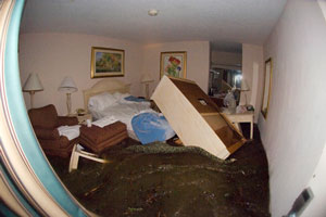
8:30 a.m. CDT - Noticed carpet along first-floor hallway is wet. Followed water into one of the rooms. Storm surge is slamming up against the window. It resembles a demonic aquarium. The wind-forced surge is literally pushing through the air conditioning unit. Water is spraying out of the vents and onto the carpet. The atmosphere is contaminated with the pungent taste of salt.
8:32 a.m. CDT - Mike is making one last attempt to shoot outside the hotel at the southeast entrance. A six-foot wave and surge just forced him back into the corner, up against building. He's trapped in the corner of the atrium. Shit. Water rapidly rising. We won't be going out front again anytime soon. It's way too dangerous.
8:40 a.m. CDT - Water is now pouring into hotel lobby, rising quickly. Will move everyone into the third -floor stairwell where we have pre-positioned blankets, mattresses and emergency supplies. Lillie Williams is going to drown if she stays in her room. A group decision has been made to rescue Ms. Williams. After forcing her door open, John and Mike carry her from the room where her furniture is already floating!
A few minutes later, the alarm on the hotel courtesy van suddenly starts to wail and that's when we see it: a 10-15-foot wave heading straight for the hotel, swelling almost gently as it approaches. But we know this won't be gentle. Seconds later, the surge turns an abandoned rental car into a two-ton battering ram. The sedan pounds against the front glass doors. Suddenly the glass shatters and the roaring surge carries the car through the lobby, forcing us into the emergency stairwell.
9:54 a.m. CDT - From inside the stairwell, Mike and I document the rapidly rising water. It's like a scene right out of the movie "Titanic," only our water seems almost animalistic. No sooner does it roar into the stairwell, grabbing at our ankles when, all of a sudden, it disappears, retreating outside as if to look for someone else to kill. As we carefully inch our way back down, the surge returns ferociously, nearly knocking us from our feet.
From outside the hotel, we hear homes and buildings tearing apart, trees cracking in half, gas lines hissing like pissed-off pythons.
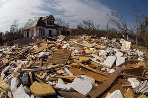
The ground level of the hotel has been completely gutted and destroyed. Only concrete walls and protruding showerheads remain. Surrounding our hotel, homes and businesses have been obliterated. Only concrete foundations remain. Where 30-year-old trees once stood, we see only craters in the ground. Gulfport looks like an ugly new planet.
After catching our breaths, we hug each other and give thanks. Having just photographed the landfall of the most catastrophic storm to ever strike the United States, we feel lucky...very lucky...to be alive.
© Jim Reed
 Dispatches are brought to you by Canon. Send Canon a message of thanks. |
|||||||||||||

Back to September 2005 Contents
|
|