|
|
|
|
by Steve Smith Travels with Binky |
 |
 My
wife and son presented me with a great toy this past Father's Day--a Garmin
GPS III Plus Global Positioning Satellite receiver. We decided the thing
had to have a name, so we called it Binky. With Binky in hand I would always
be able to know precisely (or within +/- 50 feet) where I was on this planet.
As I said, a great toy. But, on a recent assignment to Europe the Garmin
proved to be more than a mere toy, it proved in fact to be an invaluable
tool. My
wife and son presented me with a great toy this past Father's Day--a Garmin
GPS III Plus Global Positioning Satellite receiver. We decided the thing
had to have a name, so we called it Binky. With Binky in hand I would always
be able to know precisely (or within +/- 50 feet) where I was on this planet.
As I said, a great toy. But, on a recent assignment to Europe the Garmin
proved to be more than a mere toy, it proved in fact to be an invaluable
tool.
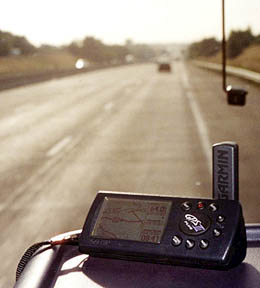
First, a bit of background. Years ago the Department of Defense decided it needed a better way for its combat "assets" to navigate. DoD developed, at huge cost, a system of satellites which would transmit low-power signals back to earth. By locking on to three or more of these signals, someone with a special receiver could pinpoint his position with amazing precision. Eventually, 24 satellites were launched into orbit. Commercial developers quickly saw the potential of the GPS system to help noncombatants navigate their way around the world, and began to produce portable receivers. Early on, GPS units were popular with pilots, boaters and hikers. Today, you can even buy a new car with a built-in GPS screen on the dashboard, a la James Bond. About the size of a cell phone, my Garmin GPS III Plus runs off of four AA batteries. It has a small LCD screen that will display several different views, including, most usefully, a moving map. The unit comes with a complete map of North America, down to the "highway-level." Optional CD-Roms let you download "street-level" maps, topo maps or world highway-level maps from your PC. You can display a variety of information, including: time of day, location by longitude/latitude, speed, distance to a specified "waypoint," and even a route. The GPS automatically traces your path across the LCD screen, leaving a "bread crumb trail" of little pixels. And for my most recent assignment this was the GPS' most useful feature. And so, back to Binky. We were shooting stories in France for Discovery Channel's food show, "Epicurious." One location was the far western tip of the Brittany peninsula, a six-hour drive from Paris. Before leaving the US I had downloaded the appropriate maps into Binky. Then, before we left Paris I set waypoints in the GPS for our Paris hotel and the little town of Roscoff. I then programmed a simple "as the crow flies" route from one point to the other. Once on the road, Binky showed us where we were on the highways of France, and gave us our speed and an approximate time and distance to our destination. Though we could generally follow our progress on a paper map, Binky always knew exactly where we were. When we arrived in Roscoff the Binkster got us within six-tenths of a mile of our new hotel. The GPS proved to be mildly helpful and greatly entertaining. The next day, we had another long drive through the Breton countryside. I programmed a new route into Binky and off we went. For the first time the GPS proved its worth. We had to navigate our way through a town filled with twists and turns and multiple road diversions, but lacking any useful road signage. Binky had no detailed view of this town, but as we wended our way through, the GPS' screen showed us that we were moving in the right direction, moving continually towards the road which would lead us out of town. In a few minutes we were on the outskirts of this confusing place, thanks to the Bink. The next day Binky came into his element. We were shooting a story in the salt marshes of Guerande. Our host led us to his salt ponds down a bewildering dirt track. We did our shooting and as we prepared to leave, my producer told me that we had to return to this exact spot later that day, but without a guide to show us the way. "Ah ha!" I exclaimed, "Let's let Binky bring us back." I waypointed our location, and we drove back out of the salt pits. When we reached the main road I again entered a waypoint. In between the two points lay a clear path of little dots--the bread crumb trail. That afternoon, we returned to the entrance to the ponds. I magnified the view on the LCD screen, gave Binky to the producer in the passenger seat and asked her to tell me when to turn. We started off slowly down the twisty dirt road. My navigator would call out, "Binky says to turn right just ahead." "Binky says to turn left." And within a few minutes we had returned to the exact spot we had left earlier that day. Without the GPS I'm not sure we would ever have found our salt pond out of the thousands in the marshes of Guerande. We might still be there today, had it not been for little Binky. I can envision myriad uses for the GPS by photojournalists. Many of us often travel to places where having a GPS receiver would prove worthwhile, even lifesaving. In the hills of the Balkans, or on the trackless steppes of central Russia you would always know where you were, and most importantly, how you got there, so that if you needed to turn around you could easily and accurately retrace your steps. I know a cinematographer who uses the GPS when he scouts rural locations. He can always be assured of finding the exact spot he had picked days or weeks before, plus the GPS will tell him the times for sunrise and sunset so he can make a beautiful shot. These little contraptions have many uses. And they don't cost much any more--usually just a couple of hundred dollars. Think about adding a GPS to your gear bag.
And thanks, Binky, you saved the day!
|
|